Trail  Le Hom - 2023-05-10_00h24m47_Cirkwi-Les_deux_chapelles - Photo

2023-05-10_00h24m47_Cirkwi-Les_deux_chapelles

 UDGI54
UDGI54

User

© OpenStreetMap contributors
Length
Length
21 km
Max alt
Max alt
218 m
Uphill gradient
Uphill gradient
578 m
Km-Effort
Km-Effort  
29 km
Min alt
Min alt
23 m
Downhill gradient
Downhill gradient
580 m
Boucle
Boucle
Yes
Creation date :
2023-05-09 22:24:47.158
Updated on :
2023-05-09 22:24:49.548

(0 Reviews)


Scan this QR Code to open this trail in the SityTrail application

FREE GPS app for hiking

Logo SityTrail SityTrail

IGN / Geographical institutes

Download SityTrail from the App Store Download SityTrail from Google Play

Logo SityTrail SityTrail Plus

The world is yours!

Download SityTrail from the App Store Download SityTrail from Google Play Download SityTrail on Huawei AppGallery

About

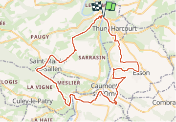
Trail of 21 km to be discovered at Normandy, Calvados, Le Hom. This trail is proposed by UDGI54.

Description

cette randonnée vous conduira à la Chapelle Bonne nouvelle située en rive droite de l'Orne, puis au retour à celle de Saint Joseph qui lui fait face en rive gauche. En chemin de belles perspective sur la vallée de l'Orne et ses méandres.

Elevation profile

Positioning

Country:
France
Region :
Normandy
Department/Province :
Calvados
Municipality :
Le Hom
Location:
Thury-Harcourt
Start:(UTM)
684219 ; 5429323 (30U) N.


Close
My subscriptions